 حجم هذا العرض: 450 × 600 بكسلالصورة بدقة كاملة
 (1,680 × 2,240 بكسل، حجم الملف: 1.1 ميجابايت، نوع الملف: image/jpeg)
 |
This image was selected as a picture of the day for . It was captioned as followed:
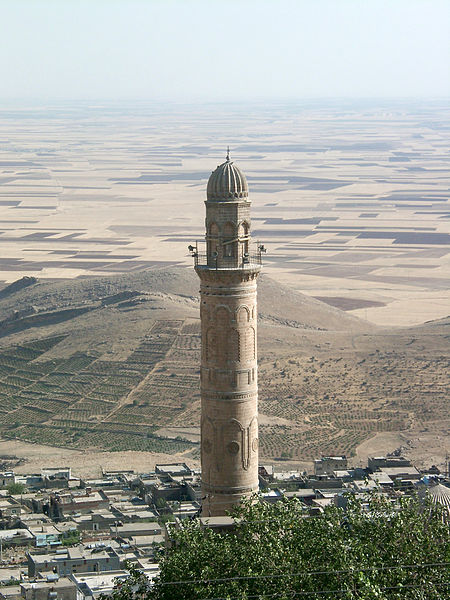
English: View from Mardin to the Mesopotamian plains with the minaret of the Reyhane Mosque in front
Asturianu: Les llanures de Mesopotami dende Mardin col minarete de Reyhane Mosque al frente
Česky: Pohled z tureckého města Mardin na Mezopotámskou nížinu. V popředí je minaret mešity Reyhane.
Cymraeg: Olygiad oddiwrth Mardin i'r Gwastadeddau Mesopotamia gyda minaret y Mosg Reyhane i'r tu flaen.
Deutsch: Blick von Mardin in Richtung Mesopotamischer Ebene mit einem Minarett der Reyhane Moschee im Vordergrund
English: View from Mardin to the Mesopotamian plains with the minaret of the Reyhane Mosque in front
Suomi: Näkymä Mardinista, Turkista mesopotamian tasankojen yli. Etualalla Reyhanen moskeija.
Português: Vista de Mardin às planícies de Mesopotamian com o minaret do Reyhane Mosque na parte dianteira.
Русский: Минарет большой мечети турецкого города Мардин на фоне месопотамской низменности.
Bân-lâm-gú: Tùi Mardin khoàⁿ--kòe-khì ê Mesopotamia pêng-goân. Thâu-chêng sī Reyhane Mosque (Hôe-kàu pài-tn̂g) ê minaret.
|
| Description |
English: View from Mardin (Turkey) to the Mesopotamian plains with the minaret of the Reyhane Mosque in front.
- Camera: Casio QV-4000
- Zoom: like 101mm small picture
- Lens aperture: f 5.6
- Time: 1/413 sec.
|
| Source |
self-made
|
| Date |
08/31/2003 at 15:09
|
| Author |
Florian Koch
French translation by Yolan Chériaux
|
Permission
(Reusing this image) |

  |
This file is licensed under Creative Commons Attribution ShareAlike 2.0 License (cc-by-sa-2.0). In short: you are free to share and make derivative works of the file under the conditions that you appropriately attribute it, and that you distribute it under this or a similar cc-by-sa license.
|
|
| Other versions |
|
| Camera location View from Mardin to the Mesopotamian plains.jpg |
37°18′38″N, 40°43′57″E 37.3105555556;40.7325
|
This and other geocoded Commons images:
|
(Info) |
وصلات
الصفحات التالية تحتوي على وصلة لهذه الصورة:
هذا الملف يحتوي معلومات إضافية، غالبا ما تكون أضيفت من قبل آلة التصوير الإلكترونية أو الماسح الضوئي المستخدم في تحميل الصورة إلى الحاسوب. إذا كان الملف قد عُدّل عما كان عليه عند تحميل الصورة فإن المعلومات الواردة هنا قد لا تعبر عن هذه الصورة المعدلة.
| منتج آلة التصوير
| CASIO
|
| نوع آلة التصوير
| QV-4000
|
| مدة التعرض
| 2421/1000000 ثانية (0.002421)
|
| العدد البؤري
| البعد البؤري/5.6
|
| تاريخ و وقت الإنتاج
| 15:09، 31 أغسطس 2003
|
| البعد البؤري للعدسة
| 20.74 ملم
|
| التوجيه
| وضعية طبيعية
|
| الدقة الأفقية
| 72 نقطة لكل بوصة
|
| الدقة الرأسية
| 72 نقطة لكل بوصة
|
| البرمجيات المستخدمة
| Adobe Photoshop 7.0
|
| تاريخ و وقت تغيير الملف
| 13:33، 3 أبريل 2005
|
| وضع Y و C
| 1
|
| برنامج التعرض
| برنامج اعتيادي
|
| نسخة Exif
| 2.1
|
| تاريخ و وقت التحويل الرقمي
| 15:09، 31 أغسطس 2003
|
| طور ضغط الصورة
| 4.012406462585
|
| تعويض التعرض
| 0
|
| أقصى غالق أرضي
| 2
|
| طور القياس بالمتر
| نمط
|
| فلاش
| 0
|
| فرق اللون
| إس آر جي بي
|

