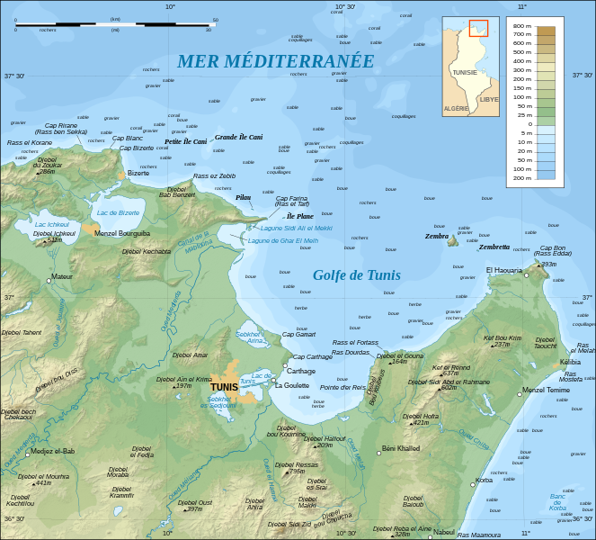
Tunis_Gulf_topo_map-fr.svg (ملف إس في جي، أبعاده 1990 × 1800 بكسل، حجم الملف: 2.57 ميجابايت)
Summary
| Camera location Tunis Gulf topo map-fr.svg |
37°00′00″N, 10°30′00″E 37;10.5 |
This and other geocoded Commons images: | (Info) |
|---|
| Description |
Topographic map in French of the Gulf of Tunis, Tunisia, with indication of the nature of the sea bottom |
|---|---|
| Source |
Own work ; |
| Date |
October 2007 |
| Author |
Eric Gaba (Sting) |
| Permission (Reusing this image) |
Attribution and Share-Alike required |
- Sujet : Carte topographique en français du Golfe de Tunis, avec indication de la nature des fonds marins ;
- Sources : Création personnelle
-
- Données topographiques : NASA Shuttle Radar Topography Mission (SRTM3 v.2) (domaine public) édité avec dlgv32 Pro et vectorisé avec Inkscape ; projection UTM ; WGS84 datum ; relief ombré (image composite d'éclairages du N-O, O et N) ;
- Références utilisées pour la bathymétrie et les données complémentaires :
-
- Cartes au 1:250 000e de l'U.S. Army (imprimées en 1956) ;
- Google Earth ;
- Carte de localisation : Image:Tunisia.svg (modifiée) créée par Philip Ronan dans le domaine public ;
- Échelle approximative : 1:372 000 (données topographiques et tracés des côtes / lacs) ;
- Note : Le relief ombré est une image bitmap encapsulée dans le fichier SVG qui augmente son poids. Si vous avez besoin d'une carte plus légère pour d'autres utilisations, supprimez l'image du relief ombré dans votre fichier ;
- Auteur : Eric Gaba (fr:Sting) ;
- Date : Octobre 2007.
 |
This SVG file uses embedded text that can be easily translated into your language. Learn more.
For SVG images, you can use this page to translate it into your language. | | | | | | | | | | | | | | | | | | +/- |
Licensing
|
وصلات
الصفحات التالية تحتوي على وصلة لهذه الصورة:

