حجم هذا العرض: 800 × 546 بكسل
الصورة بدقة كاملة (4,150 × 2,832 بكسل، حجم الملف: 3.05 ميجابايت، نوع الملف: image/png)
 A vector version of this image (SVG) is available. For more information about vector graphics, read about Commons transition to SVG. Български | | | | | | | | Bahasa Indonesia | | | | | | | | | 中文(简体) | 中文(繁體) | +/- |
 |
English text version of Image:Tectonic plates (empty).svg
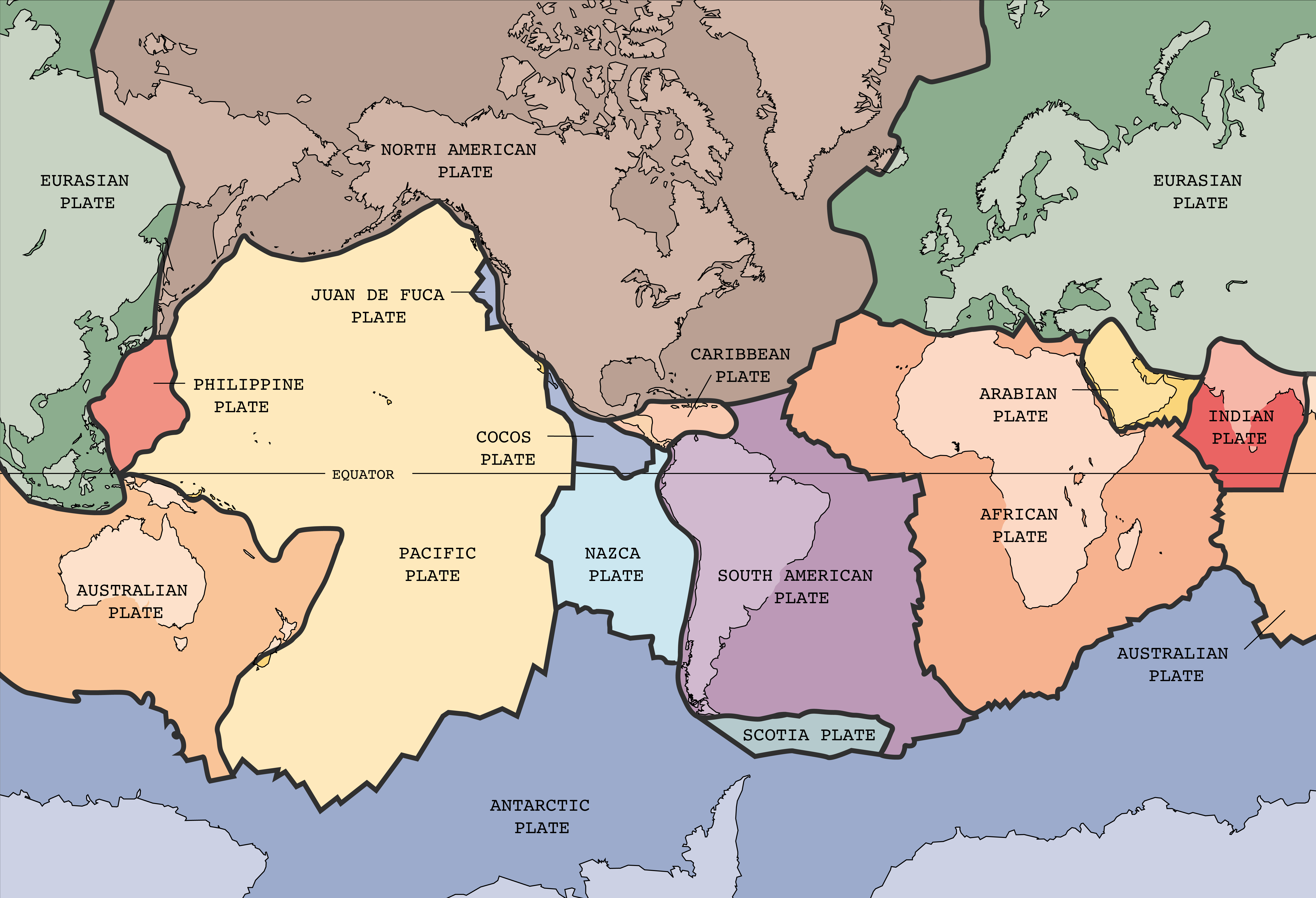
Tectonic plates of the Earth. From wikipedia.en, retrieved from USGS site: http://pubs.usgs.gov/publications/text/slabs.html
Original Image URL: [1]
![[1]](https://pubs.usgs.gov/publications/graphics/Fig1.gif)
Listed contact: mailto:jmwatson@usgs.gov
- I uploaded a larger image made from the original illustrator file. —Ævar Arnfjörð Bjarmason 02:37, 19 Feb 2005 (UTC)
| This image is in the public domain because it contains materials that originally came from the United States Geological Survey, an agency of the United States Department of Interior. For more information, see the official USGS copyright policy |
|
| This image was selected as a picture of the day for . It was captioned as followed:
English: Map of the tectonic plates of the earth
Български: Карта на тектоничните плочи на Земята
Česky: Mapa tektonických desek Země
Deutsch: Karte der tektonischen Platten der Erde
English: Map of the tectonic plates of the earth
Esperanto: Mapo de la tectonic teleroj de la tero
Español: Mapa de las placas tectónicas de la tierra.
Suomi: Maapallon tektoniset laatat.
Français : Carte des plaques tectoniques terrestres.
Italiano: Mappa delle placche tettoniche della terra
日本語: 地球の表面を覆うプレート
Lëtzebuergesch : Kaart vun den tektonesche Placke vun der Äerd.
Nederlands: Kaart met de tektonische platen van de aarde
Português: Mapa das placas tectônicas da Terra
Русский: Карта тектонических плит
Svenska: Karta över de tektoniska plattor som täcker jordens yta.
中文(简体): 地球板块结构图
|
وصلات
الصفحات التالية تحتوي على وصلة لهذه الصورة: