لا توجد دقة أعلى متوفرة.
Santa_Monica_Bay_Map.jpg (468 × 597 بكسل، حجم الملف: 283 كيلوبايت، نوع الملف: image/jpeg)
Summary
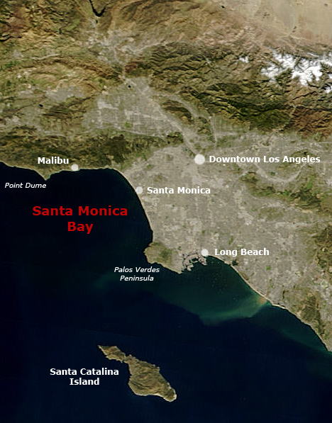
following the original text out of the english wikipedia, where it was originally uploaded: Map of Southern California with Santa Monica Bay identified
Underlying map is an aerial map obtained from NASA (original:
http://earthobservatory.nasa.gov/NaturalHazards/Archive/Nov2004/California_TMO_2004304_lrg.jpeg
The labeling is by en:User:Mikeetc
Licensing
| This work is in the public domain in the United States because it is a work of the United States Federal Government under the terms of Title 17, Chapter 1, Section 105 of the US Code. See Copyright.
Note: This only applies to works of the Federal Government and not to the work of any individual U.S. state, territory, commonwealth, county, municipality, or any other subdivision. | | | | | | | | | | | | | | | +/- |
 |
وصلات
الصفحات التالية تحتوي على وصلة لهذه الصورة:
بيانات ميتا
هذا الملف يحتوي معلومات إضافية، غالبا ما تكون أضيفت من قبل آلة التصوير الإلكترونية أو الماسح الضوئي المستخدم في تحميل الصورة إلى الحاسوب. إذا كان الملف قد عُدّل عما كان عليه عند تحميل الصورة فإن المعلومات الواردة هنا قد لا تعبر عن هذه الصورة المعدلة.
| التوجيه | وضعية طبيعية |
|---|---|
| الدقة الأفقية | 72 نقطة لكل بوصة |
| الدقة الرأسية | 72 نقطة لكل بوصة |
| البرمجيات المستخدمة | Adobe Photoshop CS2 Windows |
| تاريخ و وقت تغيير الملف | 14:52، 16 ديسمبر 2005 |
| فرق اللون | 65535 |