الرئيسيةبحث

صورة:North Carolina population map.png


JimIrwin, the copyright holder of this work, has published or hereby publishes it under the following license:
GNU head Permission is granted to copy, distribute and/or modify this document under the terms of the GNU Free Documentation license, Version 1.2 or any later version published by the Free Software Foundation; with no Invariant Sections, no Front-Cover Texts, and no Back-Cover Texts. A copy of the license is included in the section entitled "GNU Free Documentation license".

 |  |  |  |  |  |  |  |  |  |  |  |  |  |  |  |  |  |  |  |  |  |  |  |  |  |  |  | Ido |  |  |  |  |  |  |  |  |  |  |  |  |  |  |  |  |  |  |  |  |  |  |  |  |  |  |  |  |  |  |  |  |  |  |  | +/-


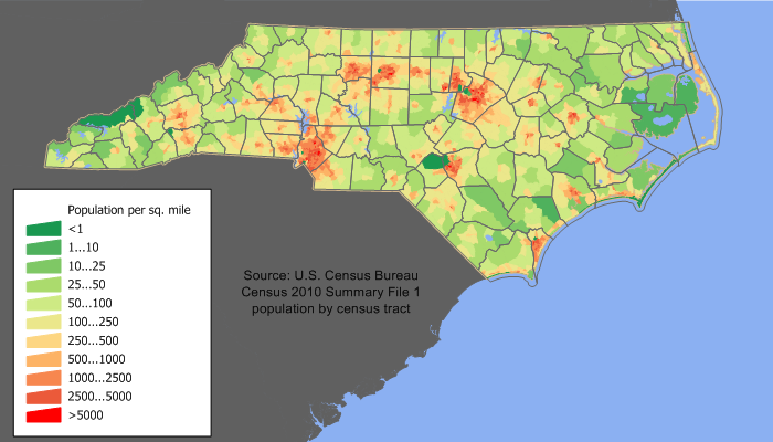
Uploaded Originally on EN WP by w:en:User:JimIrwin. 700×450 (37,416 bytes) (North Carolina population density map based on Census 2000 data. See the data lineage for the process description.)


Description

pic for NC population

Source

w:en:User:JimIrwin

Date

see history

Author

w:en:User:JimIrwin

Permission
(Reusing this image)

See below.


الصفحات التالية تحتوي على وصلة لهذه الصورة: