لا توجد دقة أعلى متوفرة.
LocationCzechoslovakia.png (250 × 229 بكسل، حجم الملف: 10 كيلوبايت، نوع الملف: image/png)
| Description |
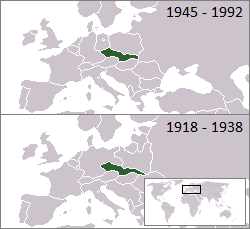
Location of Czechoslovakia 1918–1938 and 1945–1992 |
|---|---|
| Source |
From en.wikipedia |
| Date | |
| Author |
First uploaded to en: by en:User:Morwen, extended to the "first republic" by en:User:Hexagon1. |
| Permission (Reusing this image) |
see below |
 |
This map image should be recreated using vector graphics as an SVG file. This has several advantages; see Commons:Media for cleanup for more information. If an SVG form of this image is already available, please upload it. After uploading an SVG, replace this template with template {{|new image name.svg}} in this image. |
|
| | | | | | | | | | | | | | | | | | | | | | | Tiếng Việt | | | +/- |
|
| I, the copyright holder of this work, hereby release it into the public domain. This applies worldwide. In case this is not legally possible: | | | | | | | | | | | | | | | | | | | | | | | | | | | | | | | | | | | | | | | | | | | | | | | | | | | | | | | | | | | +/- |
وصلات
الصفحات التالية تحتوي على وصلة لهذه الصورة: