لا توجد دقة أعلى متوفرة.
Lage_des_Ruhrgebiets.png (176 × 234 بكسل، حجم الملف: 5 كيلوبايت، نوع الملف: image/png)
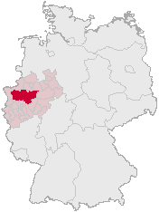
The map shows the position of the Ruhr Area in Germany
on basis of http://www.opengeodb.de and changes of de:Benutzer:Geograv
 |
Permission is granted to copy, distribute and/or modify this document under the terms of the GNU Free Documentation license, Version 1.2 or any later version published by the Free Software Foundation; with no Invariant Sections, no Front-Cover Texts, and no Back-Cover Texts. A copy of the license is included in the section entitled "GNU Free Documentation license".
| | | | | | | | | | | | | | | | | | | | | | | | | | | | Ido | | | | | | | | | | | | | | | | | | | | | | | | | | | | | | | | | | | | +/- |
Please list pages which use this map (or other versions of it) here:
Bitte listen Sie hier Seiten auf, die diese Karte (bzw. andere Versionen von ihr) nutzen hier:
وصلات
الصفحات التالية تحتوي على وصلة لهذه الصورة: