لا توجد دقة أعلى متوفرة.
Karte_Deutschland.png (188 × 235 بكسل، حجم الملف: 2 كيلوبايت، نوع الملف: image/png)
| This high-risk image, which is widely used on Wikimedia projects, has been protected to prevent vandalism. Please discuss changes on the talk page or request unprotection. |
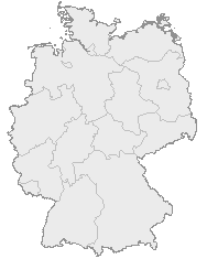
| Description |
English: Map of Germany with the borders of the 16 federal states.
Deutsch: Karte von Deutschland mit den Grenzen der 16 Bundesländer.
|
|---|---|
| Source |
OpenGeoDB |
| Date |
? |
| Author |
NN/OpenGeoDB |
| Permission (Reusing this image) |
GFDL |
 |
Permission is granted to copy, distribute and/or modify this document under the terms of the GNU Free Documentation License, Version 1.2 or any later version published by the Free Software Foundation; with no Invariant Sections, no Front-Cover Texts, and no Back-Cover Texts. A copy of the license is included in the section entitled "Text of the GNU Free Documentation License".
This image was generated with http://opengeodb.hoppe-media.com/. Permission to use it under GFDL was given by its author Akl. |
 A vector version of this image (SVG) is available. For more information about vector graphics, read about Commons transition to SVG. Български | | | | | | | | Bahasa Indonesia | | | | | | | | | 中文(简体) | 中文(繁體) | +/- |
 |
وصلات
الصفحات التالية تحتوي على وصلة لهذه الصورة: