| Description |
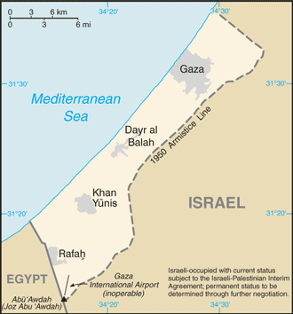
This image was copied from en.wikipedia.org. The original description was: A map of the Gaza Strip showing key towns and neighbouring countries. |
|---|---|
| Source |
Gaza Strip from CIA factbook |
| Date | |
| Author |
Taken from CIA World Factbook website on 15 August. |
| Permission (Reusing this image) |
Public domain, as is all content from the CIA factbook. |
| Other versions | Norsk tekst |
| This image is in the public domain because it contains materials that originally came from the United States Central Intelligence Agency's World Factbook.
| | | | | | | | | | +/- |
 |
وصلات
الصفحات التالية تحتوي على وصلة لهذه الصورة: