لا توجد دقة أعلى متوفرة.
EasternRomanEmpire.png (250 × 175 بكسل، حجم الملف: 7 كيلوبايت، نوع الملف: image/png)
 |
This map has been uploaded by Electionworld from en.wikipedia.org to enable the |
|
|
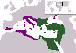
The territory in green represents the core areas held by the Eastern Roman Empire before the Muslim conquests The territory in purple represents the greatest extent of the Byzantine Empire under Emperor Justinian I
وصلات
الصفحات التالية تحتوي على وصلة لهذه الصورة: