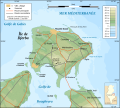
Djerba_topographic_map-ar.svg (ملف إس في جي، أبعاده 1100 × 990 بكسل، حجم الملف: 577 كيلوبايت)
Summary
| Camera location Djerba topographic map-ar.svg |
33°45′00″N, 10°55′00″E 33.75;10.9166666667 |
This and other geocoded Commons images: | (Info) |
|---|
| Description |
العربية: خارطة جربة بتونس باللغة العربية.
English: Topographic map in Arabic of Djerba in Tunisia.
Deutsch: Topografische Karte von Djerba in Tunesien in arabische Sprache
Français : Carte topographique en arabe de l'île de Djerba, Tunisie
Norsk (bokmål): Topografisk kart over Djerba i Tunisia, på arabsk.
|
||
|---|---|---|---|
| Source |
Image:Djerba topographic map-fr.svg
|
||
| Date |
2008-03-15 |
||
| Author |
Eric Gaba (translated by DrFO.Jr.Tn) |
||
| Permission (Reusing this image) |
GFDL & CC-by-SA |
||
| Other versions |
] |
English: This map was made or improved by the Wikigraphists of the Atelier graphique. You can propose maps or images to clean up and improve as well.
Esperanto: Ĉi tiu mapo estis kreita aŭ plibonigita de la Vikigrafistoj el la Grafika laborgrupo. Vi ankaŭ povas tie proponi mapojn aŭ bildojn plibonigendajn.
Español: Este mapa ha sido confeccionado o mejorado por los Wikígrafos del Atelier graphique. Puedes proponer la mejora tanto de mapas como también de imágenes.
Français : Cette carte a été créée ou améliorée par les Wikigraphistes de l'Atelier graphique. Vous pouvez également y proposer des cartes ou des images à améliorer.
Türkçe: Bu harita Atelier graphique'ten Wikigraphistes'ler tarafından yapıldı veya geliştirildi. Siz de haritalar veya resimleri temizlemek veya geliştirmek için teklif edebilirsiniz.
 |
This SVG file uses embedded text that can be easily translated into your language. Learn more.
For SVG images, you can use this page to translate it into your language. | | | | | | | | | | | | | | | | | | +/- |
Licensing:
| This file is licensed under the Creative Commons Attribution ShareAlike 3.0 Unported License. In short: you are free to share and make derivative works of the file under the conditions that you appropriately attribute it, and that you distribute it only under a license compatible with this one.
العربية | | Česky | | | | | | | | עברית | | | | | | | | | | | | +/- |


