حجم هذا العرض: 800 × 352 بكسل
الصورة بدقة كاملة (1,427 × 628 بكسل، حجم الملف: 42 كيلوبايت، نوع الملف: image/png)
Summary
| Description |
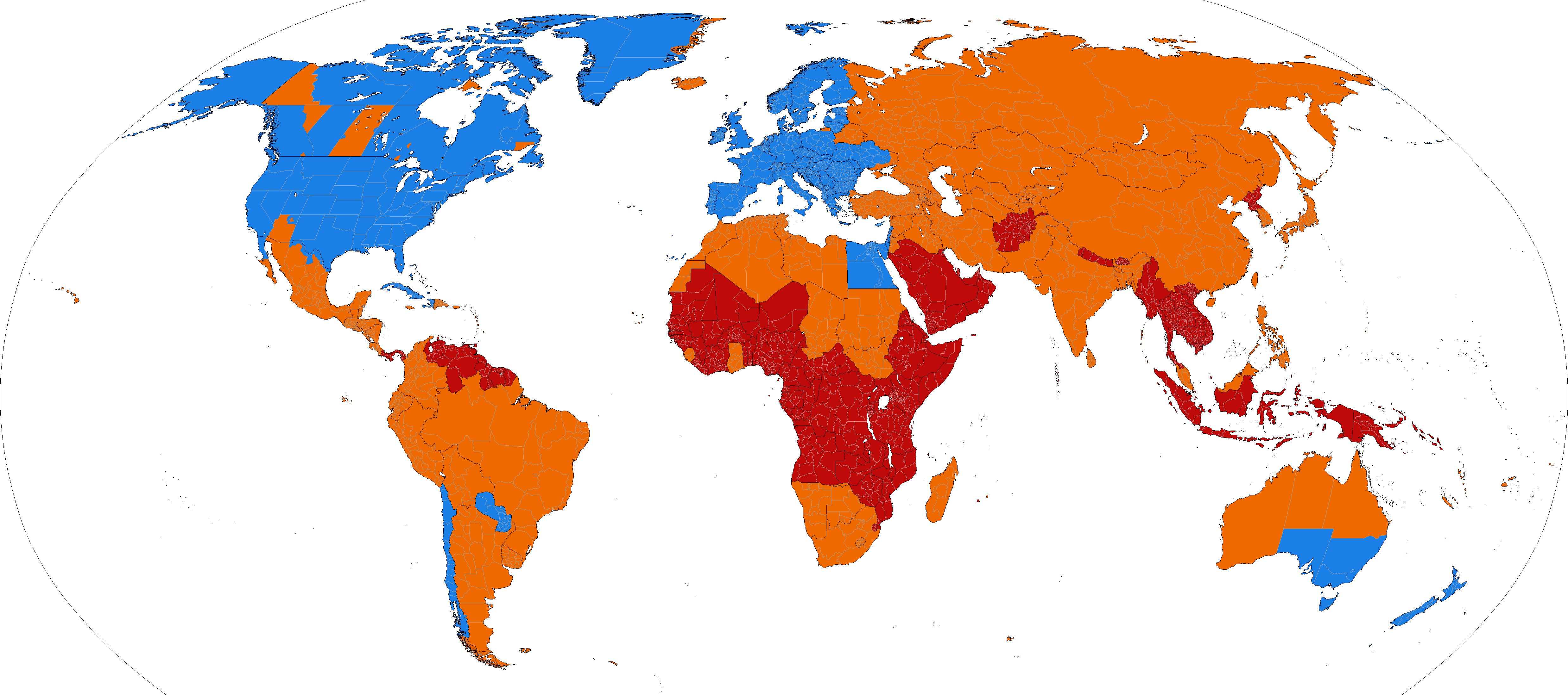
World map showing current and past daylight saving usage ██ DST used ██ DST no longer used ██ DST never used |
|---|---|
| Source |
based on Image:BlankMap-World-Subdivisions.PNG, plus the data in the tz database, plus data in the maps on the INMS's Time Zones & Daylight Saving Time page. |
| Date |
2007-04-17 |
| Author |
Paul Eggert |
| Permission (Reusing this image) |
see below |
Changes to DST rules, or discoveries about errors in historical data, would require changes to the image.
Licensing
 |
Permission is granted to copy, distribute and/or modify this document under the terms of the GNU Free Documentation license, Version 1.2 or any later version published by the Free Software Foundation; with no Invariant Sections, no Front-Cover Texts, and no Back-Cover Texts. A copy of the license is included in the section entitled "GNU Free Documentation license".
| | | | | | | | | | | | | | | | | | | | | | | | | | | | Ido | | | | | | | | | | | | | | | | | | | | | | | | | | | | | | | | | | | | +/- |
 |
This map image should be recreated using vector graphics as an SVG file. This has several advantages; see Commons:Media for cleanup for more information. If an SVG form of this image is already available, please upload it. After uploading an SVG, replace this template with template {{|new image name.svg}} in this image. |
|
| | | | | | | | | | | | | | | | | | | | | | | Tiếng Việt | | | +/- |
|
وصلات
الصفحات التالية تحتوي على وصلة لهذه الصورة: