الرئيسيةبحث

صورة:Cyprus districts named.png


Description

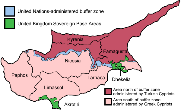
Map of the districts of Cyprus, named in English, with English annotations, and showing the Turkish Republic of Northern Cyprus, United Kingdom Sovereign Base Areas, and United Nations buffer zone. The individual maps are:

Source

Self-made, traced from public domain UN or CIA maps.

Date

June 2005

Author

User:Golbez

Permission
(Reusing this image)

Provide attribution, please. See below.

Other versions
Français :
http://commons.wikimedia.org/wiki/Image:Carte_des_districts_de_Chypre.png

I, the copyright holder of this work, hereby publish it under the following licenses:
Some rights reserved
Creative Commons Attribution iconCreative Commons Share Alike icon
This file is licensed under the Creative Commons Attribution ShareAlike license versions 2.5, 2.0, and 1.0

 |  |  |  |  |  |  |  |  |  |  |  |  |  |  |  |  |  |  |  |  |  |  |  |  | +/-

GNU head Permission is granted to copy, distribute and/or modify this document under the terms of the GNU Free Documentation license, Version 1.2 or any later version published by the Free Software Foundation; with no Invariant Sections, no Front-Cover Texts, and no Back-Cover Texts. A copy of the license is included in the section entitled "GNU Free Documentation license".

 |  |  |  |  |  |  |  |  |  |  |  |  |  |  |  |  |  |  |  |  |  |  |  |  |  |  |  | Ido |  |  |  |  |  |  |  |  |  |  |  |  |  |  |  |  |  |  |  |  |  |  |  |  |  |  |  |  |  |  |  |  |  |  |  | +/-

You may select the license of your choice.

الصفحات التالية تحتوي على وصلة لهذه الصورة: